A major satellite imagery provider has indefinitely restricted access to images of Iran and much of the Middle East following U.S. government pressure, raising alarms among humanitarian organizations and journalists who rely on the data for conflict reporting and aid coordination.
California-based Planet Labs initially implemented a 14-day delay on new imagery from the region in March but has now moved to an "indefinite" restriction under what it calls a "managed distribution" system. The company will only share selected images "on a one-off basis until the security risk has abated."
"When an entire region goes dark indefinitely, it directly affects our ability to plan evacuations, assess damage, document human rights abuses and coordinate aid delivery," said Bill Greer, a geospatial analyst who co-founded the nonprofit satellite service Common Space.
The restrictions appear to extend across most of the Middle East, including Iraq, Lebanon, Israel, and Gaza, limiting how journalists, humanitarian groups, and analysts can assess the impact of conflicts in the region. Images taken after March 9 are no longer routinely available to the company's clients.
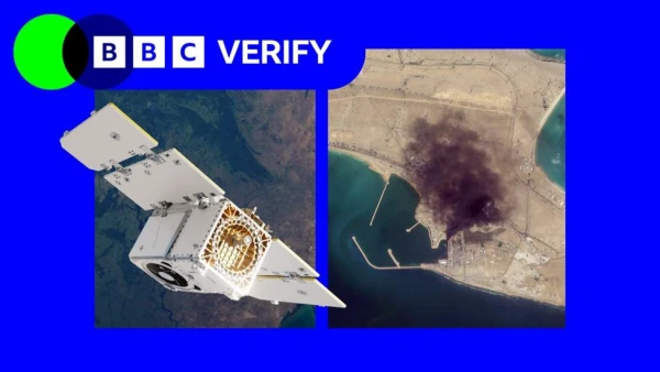
Satellite imagery has become essential for reporting from conflict zones where journalists cannot safely access scenes or where information is tightly controlled. The BBC's Verify team has used Planet imagery to investigate strikes in Iran and document changes in Gaza, where Israel restricts independent media access.
Oxfam's humanitarian lead, Magnus Corfixen, explained how his organization depends on satellite data: "We couldn't access water systems in person in Gaza, so we used satellite imagery to see whether they were still operational or destroyed. Based on that imagery, we planned what equipment to transport into the Strip."
Industry experts note that Planet's growing defense contracts with U.S. agencies like the National Geospatial Intelligence Agency and Navy create complex relationships between commercial providers and government interests.
"What we're seeing now is voluntary compliance driven by commercial incentive structures, not legal mandates," Greer observed. "When your largest customer is also the government that regulates you, the line between voluntary and involuntary gets very thin."
The restrictions have created unintended consequences, including a surge in fake satellite imagery circulating online. Amir Farhand, founder of mapping platform Soar.Atlas, reported "a massive spike in fake satellite imagery during this conflict," calling the trend "a serious problem."
News organizations like the BBC and New York Times have turned to non-U.S. alternatives, but these often provide lower-resolution images with less frequent coverage. "The imagery is blurrier. I cannot distinguish between cars, vehicles, things like that," said Christoph Koettl, a visual investigations journalist with the New York Times.
Todd Harrison, a senior fellow at the American Enterprise Institute and former U.S. Air Force captain, noted that Iran has limited satellite surveillance capability of its own, making it heavily reliant on commercial providers. "This data would be enormously valuable to Iran in its efforts to strike targets across the Middle East and assess the effectiveness of its strikes," he said.
Despite current restrictions, experts predict such limitations will become increasingly futile as the satellite imaging industry expands globally. "Because dual-use technology like this has become increasingly democratized, it is making the modern battlefield more transparent for both sides than ever before," Harrison said. "That is a fact of life the U.S. and others will have to adapt to."